Written 10:15 AM, Oct. 27th, 2010
Posted same afternoon
Saturday, the 23rd, saw us start and complete “the greatest day hike in New Zealand,” and according to some, the best in the world. 50,000 people per year hike the Tongariro Crossing, and we were lucky enough to do it in the off-season, in incredibly good conditions and with relatively few fellow hikers (probably only about 400). The Tongariro Crossing (tong-uh-REER-oh) is a one-way hike, in at one trailhead and out at another, so a few people arrange their own transportation (i.e. someone to pick them up at the end) and drive up to the trailhead, but most, like us, take a shuttle that will pick us up at the end of the day. Lyn had strongly recommended that we go with Tongariro Expeditions, which turned out to be a great choice. Their policy is that they won’t take people up to the hike if conditions aren’t good, and they won’t put people on the mountain if they wouldn’t want to be there themselves. Other companies take people up no matter the conditions, just for the money, which is shameful. The conditions on the TC can be very extreme, and can change rapidly. Lyn has done it several times and has some pretty gnarly stories of 50 km/hr winds and sub-freezing temperatures that come in quickly on a day that started warm and balmy. We were so pleased that the weather gods finally handed us a perfect day- maybe two clouds in the sky the entire day, and sun sun sun and only a small amount of wind on the way down. We met a Danish guy from Auckland at our lunch stop, who had done the TC a number of times in all seasons, and said this was the best conditions he had ever seen up there- lucky us!
We were up at 6 AM to get to the Turangi I-Site, where the expedition bus picked us up and shuttled us to the Mangetepopo trailhead, which was hopping with people, at 8 AM! The staff on the bus gave us info sheets about every segment of the trail, maps, and the essential timelines for the hike- the last bus would leave the Ketetahi trailhead on the other side at 4:30, so it was essential that we leave certain points at certain times to make sure we made it back for our pick-up. Most people hike the whole traverse in 6-8 hours (we did it in exactly 7 hours), and the company did a really great job of letting us know what to expect, and explaining the TC’s “point of no return”- the climb up Red Crater Ridge, not quite halfway in. Basically, if you get to that point and are feeling unfit or having trouble, you turn around before you get to the climb up the ridge, but if you start up the ridge and start feeling bad, you have to keep going, because the other side is more sheltered, and it’s really hard to go back down the ridge, just best to keep going. They also had every type of hiking gear available for use- hiking boots, jackets, raingear, packs, hiking poles, the whole bit. We were given so much information about how to prepare and what kind of gear to bring that we were amazed to see the lack of sense that many people up there had in regards to clothing and gear- running shoes, cotton workout pants, leather jackets, all kinds of things that could get you killed if the weather changed. We chose to borrow hiking poles (in reality, old ski poles, but they worked just fine), which were free to use, and hit the trail at about 8:20 AM.
I’ll do most of the rest of this post in photos, but I’ll explain the route a little bit- the trail goes in on the flank of Mt. Ngaurahoe (naur-uh-HOO-ee), then up the Devil’s Staircase to the South Crater, then straight through the South Crater, which is dead flat, to the climb up Red Crater Ridge, then around the rim of Red Crater, which is windy, but the ground is warm to sit on (thermally heated). From Red Crater Ridge it is a steep climb down on scree and slush to the Emerald Lakes, then through the enormous Central Crater to Blue Lake. From the edge of Blue Lake, the trail starts to zigzag sidehill down to the Ketetahi Hut, and then from the hut it is about a two hour walk downhill on the north face of Mt. Tongariro past Ketetahi Hot Springs (privately owned) and then through some lowland bush to the Ketetahi Trailhead and the end of the crossing. From here, I’ll let the pictures do most of the talking (I had a really hard time choosing only a few, so I apologize if it's a little bit of overload here):
Click on photos to enlarge
Mt. Ruapehu on the drive up.
Matt heading up the trail.
Me and Ngaurahoe (otherwise known at Mt. Doom. Look familiar?)
View of Mt. Ngaurahoe from the south crater
Matt in the South Crater
Through the crater
Looking back over south crater. You can't really see it here, but Mt. Taranaki on the southwest coast was in the distance- you can see coast to coast on a clear day from the summit of the TC.
Rimeice (spelling?) created from wind exposure
Not sure this photo shows how gnarly the climb up to Red Crater ridge was.
View into Red Crater from the summit of the crossing.
View from the top. You can see a piece of Mt. Ruapehu to the left of Ngaurahoe.
Note the steam vents behind me. The cone of Mt. N was also venting some steam.
The scree trail down from the ridge.
View to the Emerald Lakes and edge of the central crater.
This view back into the Red Crater through the Central Crater was my favorite view of the whole hike.
A couple views of the alpine vegetation for Mom and Dad. I'm pretty sure the pointy green leaves belong to a type of alpine daisy.
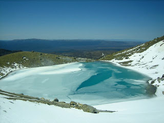
Blue Lake was frozen.
Hiking on snow down the other side.
The trail winding down to the Ketetahi hut. The near lake is Lake Rotaira, and the far one is the end of Lake Taupo.
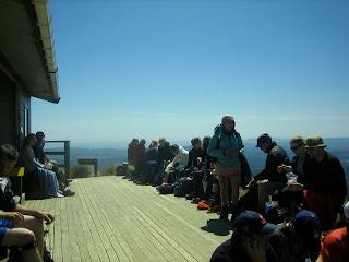
High on endorphines and the hut.
Matt and Mt. Tongariro. One hour to go!
Wacky fern on the final bush section of the hike.
We did it!
The whole thing was an amazing experience, spectacular views and quite a multicultural social experience as well. We chatted with two guys from Auckland on our way up the Devil’s Staircase, befriended a Swedish guy named Sebastian on the walk through the South Crater, and I ended up becoming the hero of an Asian girl who we first met at the bus pick-up, and who was slipping around and terrified on the climb up Red Crater Ridge. I ended up loaning her one of my hiking poles for that climb, and giving her some advice about where to place her feet, and we kept running into each other and saying hi for the rest of the hike, and she insisted on getting me on video as we hiked past Blue Lake J
It was an incredible day, we were absolutely knackered at the end of the day but very pleased at how our bodies held up (I was very pleased to have underestimated how in shape I was- turns out all that physical work on the farm got me fit enough to hike 12 miles in alpine country in 7 hours!) We showered that evening at a Holiday Park in Turangi, and treated ourselves to an amazing dinner at a local restaurant before returning to our riverside campsite, where we found two German guys van-camping as well, so we chatted with them for awhile before hitting the hay.
I think the Tongariro Crossing is probably my greatest physical achievement to date, and the challenge of it was as thrilling as the scenery and the very fact of hiking through massive volcanic craters. Matt and I both had a great time, and I’m pretty sure it ranks up there in the top 5 or 8 days of my entire life. For serious.


1 comment:
*drools*
Post a Comment