Kaitaia Library
We're back in Kaitaia after a few days exploring up to the furthest northern reaches of the country, and we had a great time. We've been totally out of the loop, news-wise, and in town this morning have been looking at the papers and found out that there is a massive tropical cyclone bearing straight for Australia, and it looks to be the worst on record to ever hit Queensland. Cyclone Yasi is enormous in size and expected to bring winds of 280km/hr according to the news here, and thousands of people are being evacuated out of the path of the storm. Nothing reported yet about us getting any effects of it over in New Zealand, so here's hoping everyone gets out of the way safely and that the devastation is as minimal as possible. We've been getting quite a few storms through, causing massive humidity and high winds, but nothing too severe in New Zealand yet. Poor Australia seems to get the brunt. We'll be keeping an eye on the forecasts and I'll keep you updated.
We headed north from Kaitaia into the blazing hot sun on Sunday afternoon, with the rock hits show on Radio Hauraki for our soundtrack. This trip towards Cape Reinga was a lot of retracing of steps for me, having been up there in 2007. It was really neat to see this part of the country again, the countryside is gorgeous and remote, the Aupouri Peninisula only about 15 kms wide most of the way up. We stopped and looked at a few places on the way up, including the harbour at Houhora Heads, which looked like this:
(Click on photos to enlarge)

We drove to Rarawa Beach, on the Pacific Coast, and had a nice little surf there. The beaches on the Pacific side are of bright white sand, incredibly soft and fine.

Matt was driving when we went back up off the beach, and we hit quite a bump in the run to get through the sand ruts, and partially ripped off the plastic covering under the oil pan- whoops. No harm done really, as it's not a vital component of the car, and we are in possession of a roll of duct tape :)
With no good options for free camping sites, we were easily convinced to spend the $15 to camp at the DOC campground at Rarawa. It was beautiful, just a quick walk from the beach, and a lovely place to camp. I took advantage of having water taps available and did a bit of laundry. I devised a pretty good system using our dishpan, wetsuit tub, dishsoap, and a bar of handsoap, and strung up the clothesline around a couple of the beautiful pines by our campsite. It worked a treat, and between the sun and wind, everything was dry by morning. Now we have enough clean clothes to last us till Kerikeri!


Evening light from our campsite


We had a leisurely morning in camp (as we tend to do- it's nice to not have to be anywhere on a schedule these days) and in the afternoon drove up to Cape Reinga, the northernmost accessible point of New Zealand, and the point at which Maori souls are said to leave New Zealand and return to the ancestral homeland of Hawaiiki. The cape has been developed a lot since I was last there, now with paved pathways, lots of good signage about the significance of the area, and most noteably, the last 20km of the highway are actually paved now! Despite the crowds of tourists, visiting Cape Reinga (ree-AIN-gah) was a very moving experience, as it is a very tapu (sacred) place to the Maori, and standing on top of the headland and looking around, you can very much see how this is a place of souls. We spent most of an hour taking it in, on a beautiful, if windy, afternoon.

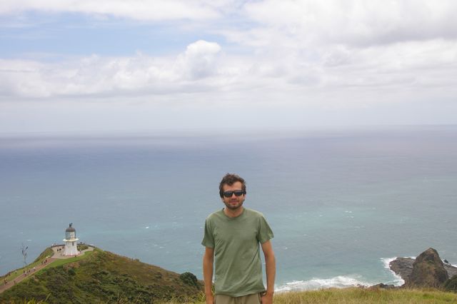
Cape Reinga lighthouse

The small bay in front of Matt is Tapotupotu Bay, where we camped Monday night

Tapotupotu Bay in front, Spirits Bay very much in the distance. The very furthest headland visible is North Cape, the actual northernmost point of land in New Zealand

"Te Rerenga Wairua (Cape Reinga) marks the separation of the Tasman Sea (to the west) and the Pacific Ocean. For Maori, these turbulent waters are where the male sea Te Moana Tepokupoku a Tiwhuki meets the female sea Te Tai o Whiteria. The whirlpools where the currents clash are like those that dance in the wake of a waka (canoe). They represent the coming together of male and female- and the creation of life." [please forgive any spelling errors in the Maori names- I can't read all of the tiny writing in the photo]


Signpost at the lighthouse.

Cape Maria van Diemen on the Tasman side


"Descending to the Underworld - the rocky point jutting out to sea is Te Reinga- the place where the spirits enter the underworld. Clinging to the rock there is an ancient kahika tree, named Te Aroha. The spirits descend to the water on steps formed by the tree's roots. They then continue on their journey to Hawaiki, the spiritual home."

"Ancient Survivor- The ancient tree you can see on the rocky point Te Reinga is known locally as a kahika. It survives, as pohutukawa trees often do. In what seem impossible conditions- even on a rockface lashed by salt winds. Unlike other pohutukawa, however, the kahika tree has never been known to flower."
There was so much significance in this place, and so many beliefs and so much history tied up in these lands. It was truly an honor to visit the Cape again, to experience such an amazing natural place and learn about what it means to those who have been here longest.
No comments:
Post a Comment