(Click on photos to enlarge)

The trip out was 27 nautical miles, through 2.5 metre seas. The swell didn't bother me until we hit some crosswinds in the last half hour that made the boat really rocky. At that point I got super queasy if I wasn't right up on the bow- I spent almost the entire journey all the way forward on the top deck.
The day was fabulously sunny and clear, and we were lucky in that the winds had shifted so that all the steam was blown up and away from the landing site, whereas usually the steam is pushed right down into the front of the crater, and you start breathing the sulfurous fumes right away.

We were all issued hard hats and gas masks on the boat, and then made the tricky landing at the jankety concrete wharf. The crew said it was one of the trickier landings they had done in awhile. The boat anchored offshore a bit, and then we went ashore 6 at a time in the inflatable tender. The skipper would keep the tender out of the way as a set of waves came in, crashing on the pier, and then would dart in between sets, and everyone on board would scramble up the old ladders and get ashore as quick as possible before the next waves came in. Exciting!


We split into two groups for the hike around the island. The guides were great and very knowledgeable, and we really did get our money's worth. Here is our experience in pictures:

That's me at the very left, hiking into the main crater.

The other half of the group, on one of the mounds of debris thrown up by the last eruption (July of 2000)


Matt in front of a big fumerole. The steam was bellowing out of there at an incredible rate, and it sounded like a jet engine.
The gas masks were used when the steam came our direction, as it was all thick with hydrogen sulfate, which reeks of rotten eggs. Every once and awhile we would get a big gulp of it accidentally, and the guides had the cure: a big box of lollies (hard candies). Sucking on a lolly clears up the throat hacking and coughing that results from breathing in the steam.


Me in front of the acidic lake in the main crater. Its current pH is -5. Very, very, very acidic!

More bubbling mud pots!

Matt and a caved-in sulfur mound.

We were given pure sulfur to taste- because it is absolutely tasteless. It only gets stinky when combined with hydrogen.

The sides of the crater everywhere were venting and steaming.

The lake in the crater.

We were taught the fun trick of cleaning 10c pieces in one of creeks of acidic runoff!

An old anchor by the wharf. The corrosive power of the air and water on the island is very intense. We had to scrub our boots in salt water before getting back onto the boat, and the guides who come out every day never wear shoes with metal grommets, because they rust away in just a few weeks.
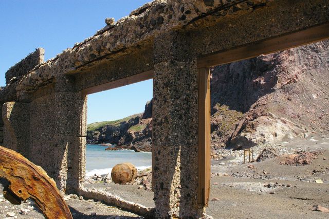
View from inside the old sulfur works, a mining operation that failed on a number of counts and was the victim of multiple eruptions, landslips, and other hazards of working on top of a volcano.

Statue of Lady Wairaka (probably spelling that wrong) at the harbour mouth at Whakatane. At the time when several Maori canoes came ashore here, it was tapu (taboo) for a woman to helm a canoe. While the men were ashore, a storm came up and the canoes were in danger of swamping, so she yelled something to the effect of "I can paddle like a man" and took up a paddle and got the women and children to safety. "Whakatane" is part of the sentence she shouted, so that was the name given to the town, harbour and river. In the background is Whale Island, which is now a wildlife sanctuary where kiwis have just been reintroduced.

On the much smoother boat ride home.

Whakatane harbour mouth and town. Look at the color of the water!

We ended the day by stopping at the West End at Ohope Beach, where Matt got his first New Zealand surf!

Perfect, perfect waves.
No comments:
Post a Comment